November 5
Testing new skis and didn't want a bunch of scratches and core shots so, I returned to Cardiff, approaching from Reynolds flat. The lower road remains patchy snow. Some of the inch or so from yesterday's storm melted back to dirt on sunny sections. The winter base begins above the lower angled rock slabs, which have also melted out to 6" or less. The average snow pack is around 16" in the upper basins. Winds have blown it around and drifting can be somewhat over 2'.
Much of the upper elevations have seen effects from the last coupla days of warm temperatures followed by winds prior to the recent snow storm. The storm laid down 1-3' medium density over a mostly crusted base. Some of these crusts are in the 2-3" thick depth and are quite slick from the fresh coat of paint. Skiing ranges from dust on supportable crust to wind pack settled powder on upper elevation shady aspects.

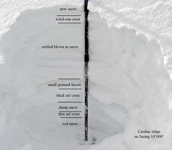
The pictured snow pit was dug in one of the filled in hollows on the Cardiac ridge massif. Perhaps 100 feet below the ridge line. Snow depth decreases rapidly above this area. New snow was a coupla inches over a wind-sun crust. Below that a foot or so of blown in snow covers a melt freeze crust, some lingering small grained facets, damp snow another crust and good snowball snow just above the ground. Shear testing only produced an easy shear at the interface between the new snow and the crust. Beating and tugging on the remaining layering produced no shears. It's locked in place.
The concern would be, with a good storm predicted later in the week, of further weakening of the new fallen snow sitting on a firm bed surface. Overloading without increased bonding could result in some fairly widespread avalanching, the first of the year.
© wowasatch.com